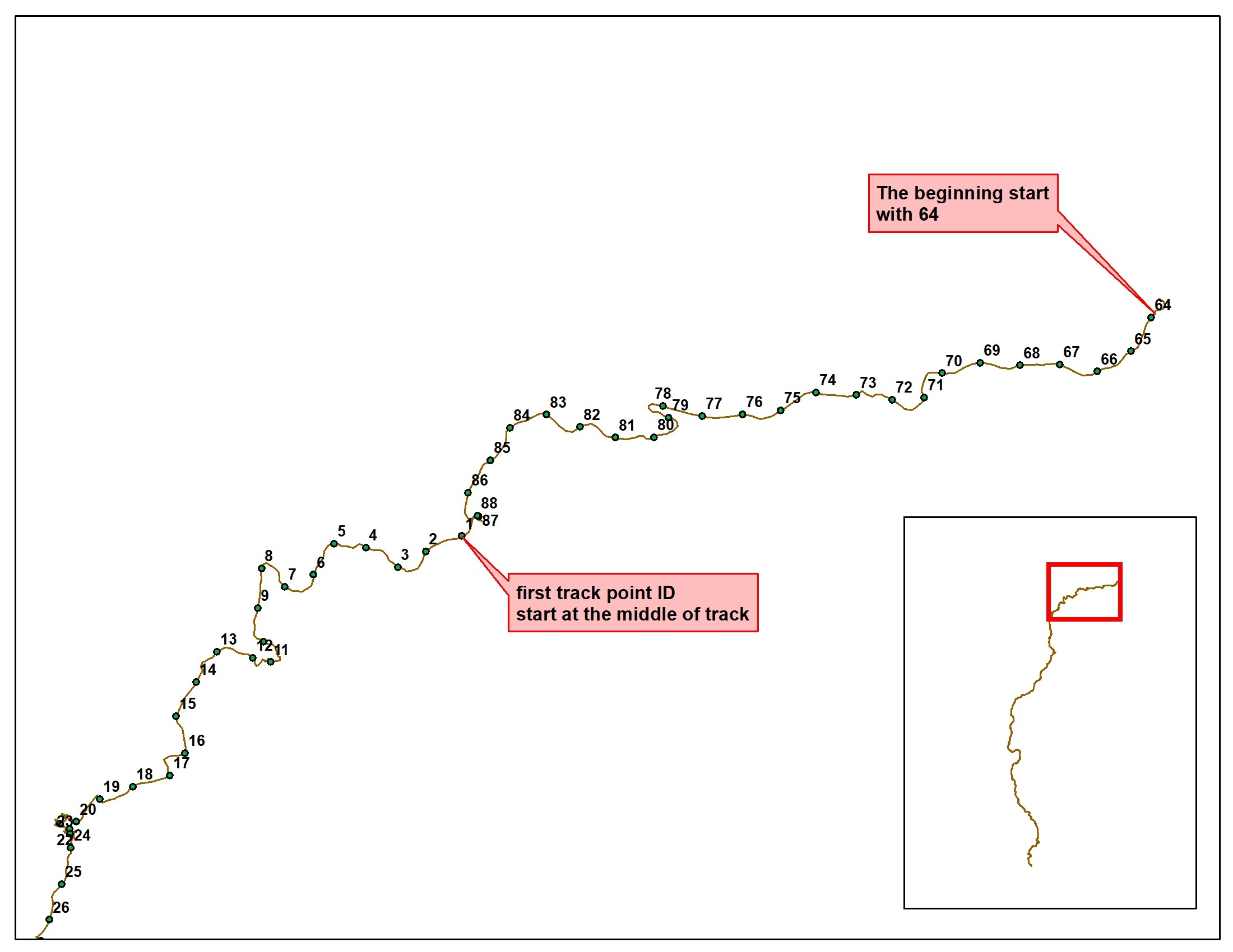
I am Okta from WCS Indonesia Program. In Indonesia, we have been doing analysis about threats occupancy using SMART Patrol data. One of the requirements of the analysis is sequential patrol tracks data. We exported the track patrol from SMART into shapefile, I thought the track from SMART should be sequential. But when we doing data processing we found that the exported track files from SMART were not sequent. We verified by converting it into a track point, it turned out that the ID was not sequential with the track path (you can see it in the attached files). Previously, I also checked the patrol track point in the SMART software and show that it was sequent. Have you any idea about this? Here is attached the track shapefile from SMART and its conversion track points.
It will be helpful if the exported patrol track can be sequent, so we don’t need to re-generate (re-digitation) the patrol track. Thank you very much.
Hello Okta,
Can you confirm which version of SMART you are using? It sounds like this may be a new issue in SMART 7, but it worked fine in SMART 6. Is that correct?
Hi Okta,
Can you also clarify how the track was created? SMART just assigns new IDs to trackpoints as they are created, so if some trackpoints were imported after the patrol was created, it would just assign them the next available IDs, which would look just like your image if trackpoints #64-87 were added to SMART after the other trackpoints were already added.
Thank you for your respon. I am using SMART 6.3.0. We did not adding waypoint/track point after created a patrol file. The patrol file was created once, then we did import waypoint and set track by import GPX data. We generated shapefile using patrol track query.
The track for the patrol is a multi-line-string with one linestring per day. The individual points for each linestring within the multilinestring are ordered sequentially. The linestrings that represent each day are not ordered, hence when you just explode the multi-line-string into the points you see something similar to the example.
Each point within the multilinestring has a z value which represents the date/time so if you sort the points by the z value you should get them in the correct order."
Hi Alex,
The data was collected using GPS device. We have checked with several data (from different devices) and found the same result. So I thought it occurred in all the data.
Hi Monica,
We extracted the track shapefiles from SMART and then converted them using R script, so where can I find the z value for the track points? Can we export the track points from SMART directly?
Hello Okta,
My apologies for the delayed response on this. Here is updated information from the developer on how you can use the Z values for sorting:
If you export the patrol tracks to shapefiles, the X,Y,Z values are in the geometry itself for each vertex.
The Z value will be a large number, something like: 1630835292000
That is an epoch/timestamp value so you can convert it to a normal date value, or just order the points on ascending Z values and the points would then be in the correct time-order.
It will depend on the tools you are using how to do that specifically, in QGIS you can do it like this:
opening the attribute table, opening the field calculator. Create a new field:
fieldname=zvalue
fieldtype=decimalnumber
expression=z($geometry)
You could do the above with the shapefile or do the geometry manipulation directly in R if you prefer. In R it would be a bit different details, but the same idea.
Let us know how it goes and if you have further issues with this.
Hi everyone,
Thank you for the advice. Great! I have checked about Z value, and it showed timestamp. I will explore more if the Z value will work with our process. This Z values is very important for us to generate track animation to give an overview of patrol movement in the field.